Q&A on Dokdo
- How is Dokdo portrayed in early Japanese maps?
-

Dokdo does not appear in early maps commissioned by the Japanese government. For instance, Dokdo is missing from the Dainihon Enkai Yochi Zenzu (Maps of Japan’s Coastal Areas), 1821, a famous collection government-commissioned maps made from actual surveys by Tadataka Inō as per orders from the shogunate during the Edo period.
Dokdo’s absence in these government-commissioned maps reflects the Japanese government’s recognition of Dokdo as non-Japanese territory.
The Kaisei Nihon Rotei Zenzu (Revised Complete Map of Japanese Lands and Roads), first published in 1779, has been presented by the government of Japan as an attempt to prove its territorial sovereignty over Dokdo. This map, produced by Sekisui Nagakubo, a Confucian scholar of the Edo period, instead, reveals that Ulleungdo and Dokdo are recognized by Japan as foreign territories.Kaisei Nihon Yochi Rotei Zenzu
(Second Edition, 1791)
Translation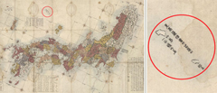
Takeshima [Ulleungdo], also known as Isotakeshima
Matsushima [Dokdo]
The two islands are located towards Goryeo [Korea] in the same way that Unshu [eastern part of today’s Shimane prefecture] is located towards Inshu [Oki Islands of Japan].
Original Text竹島 一云磯竹島
松島
見高麗猶雲州望隠州Furthermore, a quote from Inshū Shichō Gakki (Records on Observations in Oki Province) indicated on the map next to Dokdo (Matsushima) and Ulleungdo, reflects the understanding of Inshū Shichō Gakki that the Oki Islands form Japan’s northwesternmost boundary.
This is also clear from the fact that Ulleungdo (Takeshima) and Dokdo (Matsushima) are presented differently from Japanese territories in the map’s first edition as well as in the subsequent official editions: Ulleungdo and Dokdo, like mainland Joseon (Korea), are not colored and are positioned outside the longitudinal and latitudinal lines.


- (03172) 60 Sajikro 8-gil, Jongno-gu, Seoul, Republic of Korea
- Tel : +82-2-2100-2114 Fax : +82-2-2100-7999
- All rights to this website belong to the Ministry of Foreign Affairs, Republic of Korea
- COPYRIGHT © 2014 MOFA ALL RIGHTS RESERVED.